This article is also available in PDF format.
|
Hawara is situated 90 km south of modern Cairo. It is the site of an eroded mud-brick pyramid. It is also the site of the nearby labyrinth mentioned in ancient Greek texts. The term 'labyrinth' here is used for a vast complex of buildings, and is not what we usually think of as a labyrinth such as in gardens or cathedrals. In the 5th century BC Greek text Herodotus Histories, Book II, Heredotus, who was a historian and geographer, visited the then still existing above ground labyrinth, and was told of a subterranean labyrinth: [148] Now, they decided to build monuments together to leave for posterity, and having reached this decision they constructed a labyrinth just beyond the lake of Moeris, very close to the place called Crocodilopolis. I have personally seen it, and it defies description. If someone put together all the strongholds and public monuments of the Greeks, it would be obvious that less labour and money had been expended on them than on this labyrinth—and I say this despite the fact that the temples in Ephesus and Samos are remarkable structures. The pyramids, of course, beggar description and each of them is the equivalent of a number of sizeable Greek edifices, but the labyrinth outstrips even the pyramids. It has twelve roofed courtyards, six in a row to the north and six with their entrances directly opposite them in a row to the south. A single outside wall surrounds them all. The labyrinth has rooms on two levels—an underground level and an above-ground level on top of it—and there are three thousand rooms in all, with each level containing fifteen hundred. I myself went through the ground-level rooms and saw them, and so I speak from firsthand knowledge, but the underground ones were only described to me. The Egyptians who are in charge of the labyrinth absolutely refused to show the underground rooms, on the grounds that there lie the tombs of the kings who originally built the labyrinth and those of the sacred crocodiles as well. So as far as the underground rooms are concerned I can only pass on what I was told, but the upper rooms, which I personally saw, seem almost superhuman edifices. For instance, the corridors from chamber to chamber and the winding passages through the courtyards are so complicated that they were a source of endless amazement; we would pass from a courtyard to some rooms, and from the rooms to colonnades, from where we would move on to other chambers and then find ourselves back at a different set of courtyards. The roof of the whole complex is made out of stone, as are the walls; the walls are covered with carvings of figures; and every colonnaded courtyard is made out of blocks of fitted white stone. By the corner where the labyrinth ends there is a pyramid forty fathoms in height, with huge figures carved on its surface. The approach to the pyramid has been built underground. I doubt if they actually counted the number of rooms. It is probably an estimate, but it nevertheless impressed him. Later Greek writers also mention the labyrinth, but they probably never visited it themselves. After Herodotus visited the above ground structures, the labyrinth was gradually dismantled and quarried for stone by local people.
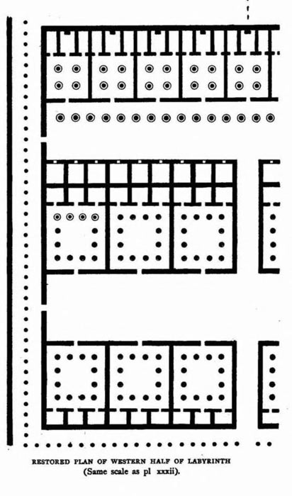
In 1889, Sir Flinders Petrie, an English Egyptologist and archaeologist, surveyed Hawara. He found at the western side of the pyramid some foundations of the structure. He discovered a vast artificial stone platform, 5 meters (16 feet) below the sand, measuring approximately 304 meters (997 feet) by 244 meters (800 feet), which he interpreted as the foundation of the Labyrinth. He argued that the structure itself had been dismantled in antiquity, its stones repurposed for other buildings. In his The Labyrinth Gerzeh and Mazghuneh (1912) he gives his reconstructed base plan of the small section he excavated:
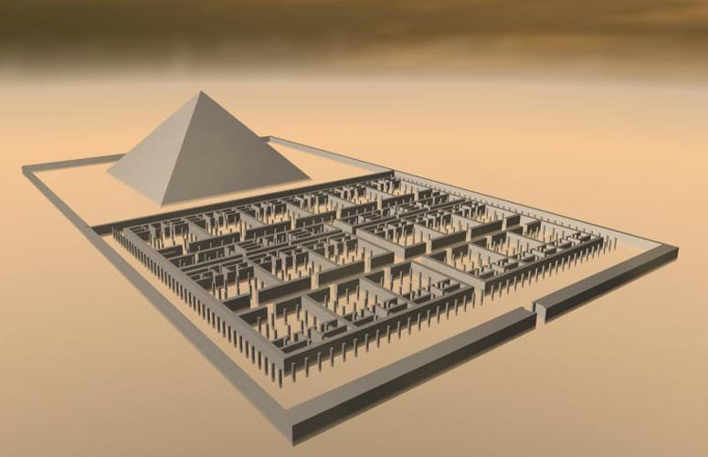
A 3D model of the above ground Labyrinth based on a drawing by Petrie, to give an idea of the scale of the structure.
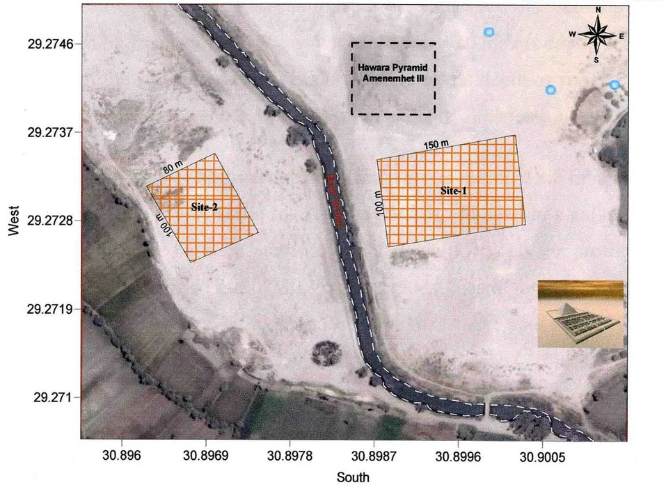
The above ground labyrinth complex is gone forever. This labyrinth was built on bedrock. In 2008 the Mataha Expedition, a cooperation by the NRIAG (National Research Institute of Astronomy and Geophysics) and the Ghent University (in Belgium), detected grid-like subterranean structures beneath Petrie’s foundation of the above ground labyrinth. This proved the claim by Herodotus that there is another labyrinth underground, in the bedrock. Their ground-penetrating radar discovered a vast complex of interconnected walls and chambers beneath the surface. Although the scans were made with the cooperation of the Egyptian authorities, Dr Zahi Hawass requested to stop communicating their results, and intimidated the Mataha Expedition team members with Egyptian National Security sanctions (for publicly sharing the geophysical results). In June 2010, the Mataha Expedition team decided to post their findings on the labyrinthofegypt.com website (original website was taken down): The Mataha – expedition geophysic research confirms the presence of archaeological features at the labyrinth area south of the Hawara pyramid of Amenemhet III. These features covering an underground area of several hectares, have the prominent signature of vertical walls on the geophysical results. The vertical walls with an average thickness of several meters, are connected to shape nearly closed rooms, which are interpreted to be huge in number. Consequently, the geophysic survey initiated with the permission of Dr. Zahi Hawass the president of the Supreme Council of Antiquities, and conducted by the National Research Institute of Astronomy and Geophysics (Helwan, Cairo) with the support of Ghent University, can now officially verify the occurrence of big parts of the Labyrinth as described by the classic authors at the study area. The Labyrinth data are acquired mainly from 2 scanned surfaces at the labyrinth area south of the pyramid. One scan survey of 150m by 100m on the right site of the Bahr Wahbi canal, and one on the left site (80m by 100m). Two considerations regarding the conclusion. First, seen the survey provided only two big puzzles; the total size and shape of the labyrinth can not yet been concluded. Secondly, the data of the labyrinth are accurate, because of the exceptional dimensions of the structure, but groundwater affected the consistency of the survey. The partial defacement of the data is due to the high salinity of the shallow subsurface water and the seasonal fluctuation of this level. So, we recommend also another episode of geophysical survey after the dewatering project to enhance the outcome to great extent. The scans reached a depth of 8 to 10 meters (26 to 33 feet) in granite bedrock. The two areas scanned (which are only two small fractions of the labyrinth) on either side of the canal:
One area is 150 meters by 100 meters. the other is 80 meters by 100 meters.
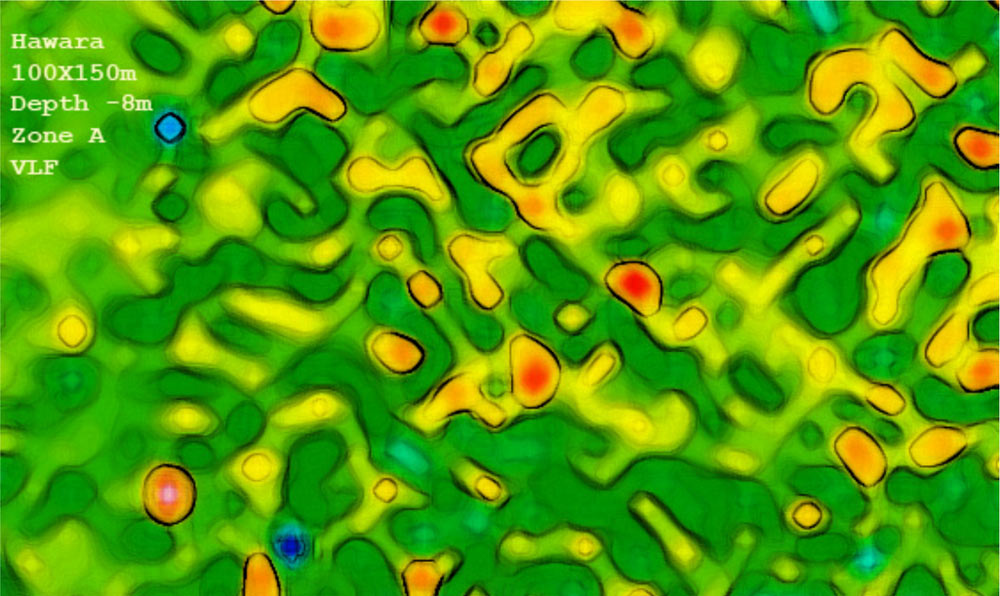
One of the scans, using very low frequency, of site 1:
Credit: National Research Institute for Astronomy and Geophysics.
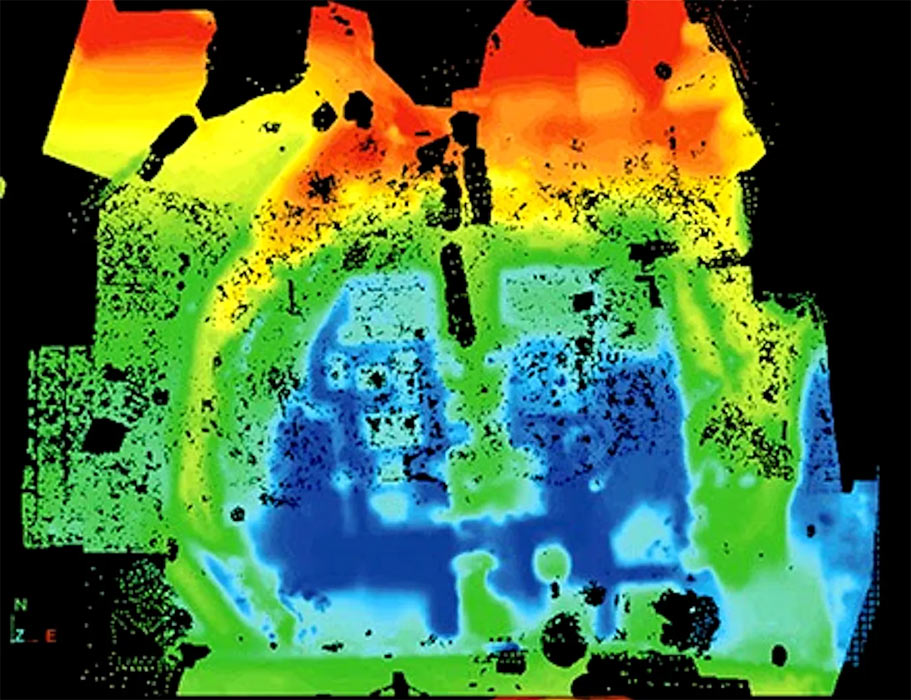
In 2015, Timothy Akers, a former military tech researcher and programmer at RAF Menwith Hill with expertise in satellite imaging presented in a private briefing in Harrogate, UK his findings of a vast subterranean structure at Hawara. This complex constitutes at least three levels underground, not counting the once above ground labyrinth. He had his high frequency satellite scans (obtained via processed private agencies) processed by his friends who were still in the military industrial complex using advanced processing techniques that would yield a three-dimensional image. They became known as the Merlin Burrows scans. Merlin Burrows is a UK-based company specializing in advanced satellite imaging. They utilize advanced satellite sciences and non invasive proprietary scanning technologies to "slice" through earth and water to reveal hidden artifacts. Akers said: "This tech can map the underground in 3D up to 5 kilometers deep, distinguishing between granite, diorite, limestone—even mapping voids, tunnels, and metallic anomalies with uncanny precision. Down to the size of a golden watch." (Labyrinth of Egypt) The scans revealed vast chambers with massive walls, and great halls at depths (from the present surface) of 40, 60, 80, 100 meters (130, 200, 260, 330 feet) and deeper. They also showed a central open space connecting several of these layers, like the atrium of a shopping mall. The several levels converge in this grand central hall, 40 meters wide and 100 meters long. Strangely inside this hall is a free standing metallic object: "The central object is hard to classify—it appears metallic, not stone or wood... Its material signature is unlike anything I’ve seen in my entire career." They have no idea what it could be. There is also a domed hall 30 meters below ground level "matching the size of the Pantheon in Rome". The entire size of the subterranean structure is estimated at approximately ten (European) football fields. The underground structures are connected to the nearby pyramid where there is a direct access. However, the tunnel entrance to the pyramid is presently flooded to a depth of 4-5 m by groundwater. The groundwater is limited to the foundation of the (once) above ground labyrinth. The subterranean structures are not flooded. Akers said that Zahi Hawass', the former head of Egypt’s Supreme Council of Antiquities, is standing in the way. He still denies the possibility of the subterranean labyrinth’s existence, and is blocking access to Hawara. In spite of the discoveries, the Egyptian authorities are not conducting any excavations. In regard to the scans, they took several scans from different angles because of the satellites positions. They all have to be properly combined and interpreted. In the images below, the five subterranean levels are compressed into one. According to color code, yellow is nearest to the top, then red, green, light blue, and finally dark blue at the deepest level. I guess, the atrium they talk about is in the middle, upper half of the images below. Images from Labyrinth of Egypt:
Inverted version of the scan, reversing the colors to make it more obvious what is high or low to the lay person.
The atrium is in the center upper half. In the center is a kind of gate with a 40 by 40 meters (130 x 130 feet) square hall. Below that to the right is circular hall.
According to the local Egyptian people, the entire Giza plateau is fill of subterranean tunnels and rooms, some very ancient (Atlantean), some more recent from the Egyptian dynasties. Most are closed to the public. So, it is not a surprise that there is also a vast subterranean complex at Hawara too. Who knows what's down there? |